Auglaize-Flatrock Watershed Management Plan
Update:
The Auglaize-Flatrock WMP is completed. The plan is available for viewing HERE.
Flatrock-Creek-Auglaize-WMPDownload
Dec. 2021 Flatrock/Auglaize WMP Project Update
Progress continues to be made on the development of the Flatrock/Auglaize Watershed Management Plan. As an example of the information that is being gathered and summarized, here is an excerpt from the Plan for the Bohnke Ditch subwatershed.
The Bohnke Ditch subwatershed is approximately 14,694 acres in size and has 34 miles of streams. According to the 303(d) and 305(b) List of Impaired Waters, 4.48 miles of streams are classified as impaired for Impaired Biotic Communities. Approximately 20 miles of streams have inadequate filter strips and 11.4 miles of streams are experiencing bank erosion problems. The main land uses are 88% agriculture, 6% forest, 5% open space/park, 0.6% grassland, 0.4% residential, and 0.05% open water. Historically, nearly the entire subwatershed was covered in wetlands however only 0.1% of the original acres remain. There are 2 unsewered communities, Boston and Zulu in the subwatershed. Nearly 100% of the soil types in the subwatershed are classified as “very limited” for septic system usage. There are 2 livestock operations and 4 National Pollution Discharge Elimination System facilities. Sixty-eight percent of soils have a slow infiltration rate when thoroughly wet, and 30.98% of soils have a very slow infiltration rate. There are no Brownfield, Superfund or Wellhead Protection areas present. Substantial flooding occurs regularly along the mainstem of Bohnke Ditch where it is classified as floodplain.
Oct. 2021 Flatrock/Auglaize WMP Project Update
The Steering Committee and Allen SWCD asked Rodney Renkenberger, the Executive Director of the Maumee River Basin Commission, to study and comment on the flooding problems in the Auglaize/Flatrock WMP project area. Rodney attended the July Steering Committee meeting and presented his findings, “Profiling the Flatrock – Floodplain Analysis.”
He began his study by establishing the amount of fall (grade change) in Flatrock Creek from inception to where it enters the Auglaize River. FEMA data was used, where possible. However, FEMA tends to focus on studying larger watersheds and has only studied about 5,000 feet of the Flatrock corridor. Rodney suggested that the Steering Committee identify the need for a complete FEMA study in the action table of the WMP and reach out to congressmen and officials and request to elaborate on the study. A detailed study would provide a profile of the bottom of the channel and the different flood frequency elevations.
Using his own methods, Rodney digitized Flatrock Creek. The stationing has been matched with the detailed analysis conducted by Paulding County.
His findings:
Flatrock Creek only has 0 .02% grade in Paulding County.
The static water level at the Indiana/Ohio state line is 4-4.5 feet. The static water level impacts the land area from the State Line bridge to Lincoln Hwy.
There is a 2.4 feet hydraulic jump in the channel near Lincoln Hwy. Further studies should be conducted to determine why the hydraulic jump is present.
The Steering Committee will consider Rodney’s findings as they continue to develop the Watershed Management Plan.
May 2021 Flatrock/Auglaize WMP Project Update
The Allen County SWCD has hired Consultant Bruce Cleland with Tetra Tech to assist with the development of the watershed management plan. Bruce will summarize water quality monitoring data for sites 401 – 406 in the Flatrock watershed. This task will focus on spatial differences and temporal variation between these locations for key parameters — notably, nutrients (total phosphorus, dissolved reactive phosphorus, NO2+NO3), sediment (total suspended solids, turbidity), and bacteria (E. coli, total coliform). He will also develop flow estimates for each of the District’s monitoring sites. Patterns will be examined relative to any available stream flow and precipitation data, as well as potentially relevant USGS gage information.
Bruce will also prepare a supplemental assessment report that summarizes water quality data. Water quality results will be described in the context of flow conditions using a duration curve framework. This technical analysis will also consider streambank condition, windshield survey results, field transect data, and available stream cross-section / flow measurements.
We’re excited to have Bruce on the project and look forward to incorporating his assessment document into appropriate sections of the Flatrock – Auglaize WMP.
Selecting critical areas. Critical Areas are defined as areas where watershed management plan implementation can remediate nonpoint source pollution sources in order to improve water quality. Steering Committee members are processing research data to determine what areas of the Auglaize/Flatrock watershed should be identified as critical. They are considering land use, water quality, habitat, and flooding conditions to help them make their decisions.
Feb. 2021 Project Update
Selecting critical areas. Critical Areas are defined as areas where watershed management plan implementation can remediate nonpoint source pollution sources in order to improve water quality.
Steering Committee members are processing research data to determine what areas of the Auglaize/Flatrock watershed should be identified as critical. They are considering land use, water quality, habitat, and flooding conditions to help them make their decisions.
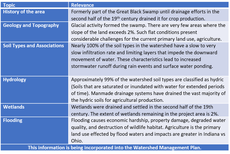
Flatrock/Auglaize Watershed Management Plan Project Update Sept. 2020
In order to identify and substantiate resource concerns in the Flatrock
Creek watershed, the project team collected, organized, and analyzed
information on the following topics to determine relevance to the health of the
watershed. The following table contains a partial summary of the findings.
The team also collected information on the following topics which will be reported on in the next project update: sewered and unsewered communities; combined sewer overflows; land use; leaking underground storage tanks; threatened and endangered species; bank erosion; filter strip usage; water quality; livestock operations; point source dischargers; and other planning efforts.
For more information, contact Sharon Partridge at the Allen County SWCD, 260-484-5848 ext. 8430.
*******************
The Allen County, Indiana Soil and Water Conservation District has received a Water Quality Planning Grant from the Indiana Department of Environmental Management to develop a watershed management plan for the Flatrock Creek/ Auglaize River watershed. This watershed is located in the SE corner of Allen County, Indiana, the NE corner of Adams County, Indiana, and portions of Paulding and Van Wert Counties in Ohio. The grant period is Nov. 26, 2019 – Dec. 25, 2021.
What is a Watershed Management Plan?
A watershed management plan identifies problems and threats to water resources and develops a framework to address these issues. It is intended to be a practical tool with specific recommendations on practices to improve and sustain water quality.
Its primary purpose is to guide citizens, watershed coordinators, resource managers, policy makers, and community organizations to restore and protect water quality in the rivers, streams, and wetlands in the Flatrock/Auglaize watershed.
It is developed using a watershed planning process that includes steps to characterize existing conditions, identify and prioritize problems, define management objectives, and develop protection or remediation strategies.
This planning effort will be led by a Steering Committee comprised of local stakeholders (citizens, businesses, governments, non-governmental organizations…) who are most knowledgeable of the needs of the watershed.
| Steering Committee | |
| Members | Affiliation |
| Dale Anderson | Farmer |
| Mark Anderson | Farmer |
| Lindsey Bluhm | Indiana State Department of Agriculture |
| Tim Bomba | USDA, Natural Resources Conservation Service |
| Pat Brames | Farmer |
| Jeremy Freimuth | Allen County Surveyors Office |
| Matt Fuelling | Ebberts Field Seeds, Agribusiness |
| Ron Funk | Farmer |
| Brent Hoffman | Hoffman Bulldozing & Farm Services, Inc. |
| Matt Jarrett | Allen County Surveyors Office |
| Greg Kneubuhler | G&K Concepts, Agribusiness |
| Brad Kohlhagen | Adams County Purdue Extension Service |
| Greg Lake | Allen County Soil & Water Conservation District |
| Austin Miller | Farmer |
| Tom Miller | Allen County Soil & Water Conservation District |
| John Nidlinger | Farmer |
| Larry Oberley | Town of Monroeville |
| Seth Owens | VanWert County Soil & Water Conservation District |
| Sharon Partridge | Allen County Soil & Water Conservation District |
| Leslie Robertson | Farmer |
| Troy Robertson | Farmer |
| Ron Roy | Ag Plus, Agribusiness |
| Brooke Rudicel | Allen County Soil & Water Conservation District |
| Barry Scherer | Adams County Regional Sewer District |
| Courtney Scherer | Allen County Soil & Water Conservation District |
| Nathan Scherer | Adams County Health Department |
| Stephanie Singer | The Nature Conservancy |
| Scott Thompson | Allen County Soil & Water Conservation District |
| Kristi Todd | Indiana Department of Environmental Management |
| Eugene Trabel | Farmer |
| Patrick Troyer | Paulding County Soil & Water Conservation Service |
| Sandy Voglewede | Adams County Soil & Water Conservation Service |
| Mike Werling | Allen County Soil & Water Conservation District |
| James Wolff | Allen County Purdue Extension Service |
The project area covers 96,580 acres. For research and planning purposes, the total project area will be sub-divided into 5 subwatershed: Wildcat Creek; Headwaters Flatrock Creek; Bohnke Ditch; Hoffman Creek; and Brown Ditch.
For more information about the Flatrock/Auglaize Watershed Management Plan project, contact the Allen County SWCD.
June 22, 2020 Update
Flatrock/Auglaize Watershed Management Plan
The Steering Committee and staff have been collecting information about the Flatrock/Auglaize watershed and comparing it to the List of Concerns that the Steering Committee and Technical Advisors developed in their first two meetings.
| Stakeholder Concerns | |
| Concerns | Relevance |
| Flooding | Corn and soybean fodder washing from fields plugging ditches. Unresolved issue of a limestone shelf in the Flatrock downstream of the Indiana/Ohio state line that holds back water. Lack of coordination between Indiana and Ohio drainage authorities contributes to flooding problems. |
| Log Jams | Log jams in Ohio hold back water in the Flatrock Creek and cause flooding. |
| Stream/Ditch Bank Erosion | Prevalent throughout the watershed especially in areas where stream/ditch banks are subject to flooding. |
| Need for more Water Quality Research | Two sub-watersheds have their headwaters in Ohio and the contribution to poor water quality from the Ohio area is unknown. |
| Lack of Water Quality Education/Outreach | Residents unaware of resource concerns. No materials/activities to date specifically addressing the project area. |
| High E. coli Levels | Historic water quality data collected at Sample Site 401 identifies 34% of E.coli reading exceed the water quality target level. |
| High Turbidity Levels | Historic water quality data collected at Sample Site 401 identifies 100% of Turbidity readings exceed the water quality target level. |
| High Phosphorus Levels | Historic water quality data collected at Sample Site 401 identifies 79% of Total Phosphorus readings exceed the water quality target level. |
| Faulty Septic Systems | Failing systems. Older homes where waste is piped straight to the streams/ditches. |
| Excessive Nutrients entering Streams/Ditches | Runoff from farmland where manure has been land applied. Livestock access to open water. Faulty septic systems. |
| Excessive Sediment in Water Column | Unbuffered agricultural runoff. Eroding stream/ditch banks. |
| Lack of Filter Strips | Unbuffered agricultural runoff. Eroding stream/ditch banks. |
| No Residue/Cover on Ag Fields | Only 10% of fields are in no-till/cover crops. |
| Unbuffered Tile Field Inlets | Tile field inlets provide a direct conduit for sediment and other pollutants to flow directly into the tile system. |
| Barnyard Runoff | Stormwater picks up pollutants from barnyards and carries them to open water. |
| Stream/Ditches Listed as Impaired by IDEM | 303d listed segments for nutrients and impaired biotic communities. |
A Windshield Survey was completed in April of 2020. Just like it sounds, windshield surveys are done from a vehicle. This type of data collection is useful for verifying digital information and for pinpointing problem areas. Teams of two to three people drove every road in the project area looking for evidence of the concerns listed by stakeholders and technical advisors. The primary concerns that were identified are listed in the table below.
2020 Windshield Survey: Primary Concerns
| County | Total # of Points Observed | Log Jams | Bank Erosion | Flooding | Unbuffered Field Tile Inlets |
| Allen | 180 | 1 | 77 | 3 | 117 |
| Adams | 130 | 0 | 3 | 0 | 182 |
| Paulding | 27 | 4 | 5 | 1 | 4 |
| Van Wert | 21 | 0 | 1 | 0 | 15 |
| Total | 358 | 5 | 86 | 4 | 318 |
Windshield Survey: Other Observations
Numerous sites lack adequate filter strips adjacent to streams/ditches.
Invasive species were observed at a limited number of sites.
Illegal dumping was observed at a limited number of sites.
Improper application of livestock manure was observed at a limited number of sites.
Few sites were observed where flooding has impacted property long-term.
The project team will continue to investigate all of the items on the stakeholder List of Concerns and report back on their findings.